
Maps & Bike Routes
Explore bicycle maps, trail guides, route planning resources, and the Glastonbury Bicycle Master Plan route. Whether you’re commuting, training, touring, or exploring local trails, these resources can help you plan your next ride.
Glastonbury Bicycle Maps
Glastonbury Bicycle Master Plan Route Description
A detailed, print-friendly description of the proposed bicycle route through Glastonbury.
On-Road Bikeways in Glastonbury
View or download a PDF map of existing and proposed on-road bicycle facilities in Glastonbury.
Off-Road Bikeways in Glastonbury
View or download a PDF map of existing and proposed off-road bicycle facilities in Glastonbury.
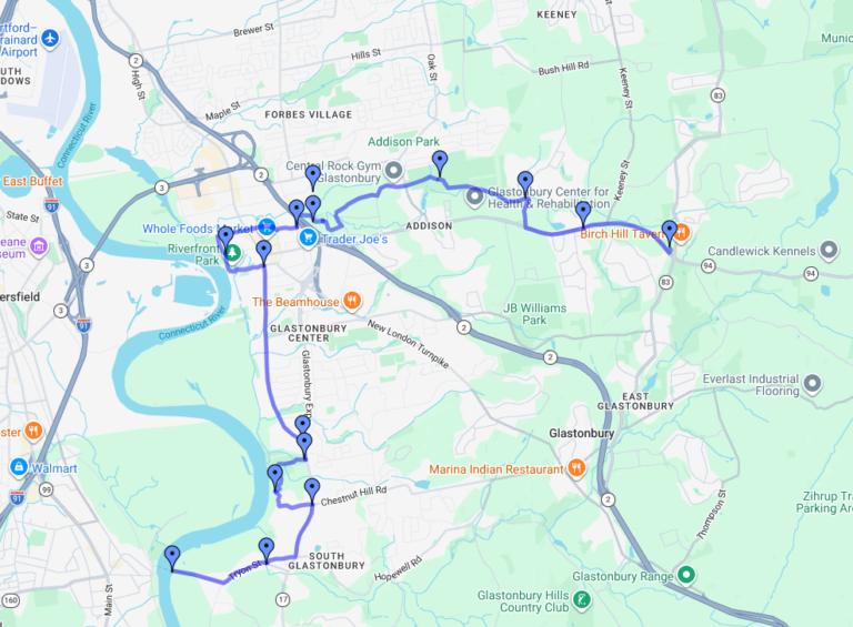
Glastonbury Bicycle Master Plan: Google Map
Maps & Bike Routes in Connecticut
Connecticut Bike Routes
This website has been developed by three Connecticut based bicycle enthusiasts as a service to the cycling community. Search and find detailed information on over 400 bike routes, most of which are located entirely in Connecticut.
TrailLink
A free service of Rails-to-Trails Conservancy, a non-profit dedicated to assisting local communities in converting unused railroad corridors into trails.
East Coast Greenway
By connecting existing and planned shared-use trails, a continuous, traffic-free route is being formed, serving self-powered users of all abilities and ages. 3,000 miles long, the Greenway links Calais, Maine at the Canadian border with Key West, Florida.
Farmington River Trail
One of the most picturesque and historic greenways in New England. The Connecticut section from New Haven to Suffield runs fifty four miles through eleven towns and connects with many more biking and walking trails.
Hop River State Park Trail
Bolton to Windham – 12 miles – gravel – open to public use – paving proposed.
Route Mapping Services
The best way to share trips, connect with other travelers and find great new things to do.
Get directions (walking, biking, public transport).
Create training maps or use those already logged by our members.
Sustained efforts by parents, schools, community leaders and local, state, and federal governments to improve the health and well-being of children by enabling and encouraging them to walk and bicycle to school.
